


Winter Weather Preparedness Week for NC is December 3rd – 9th
With proper planning and preparation, you can limit or even mitigate the impacts from winter storms. North Carolina’s proximity to the Appalachian Mountains, Atlantic Ocean, Gulf Stream and Gulf of Mexico creates complex winter weather forecasts. This winter, the state will likely be impacted by an El Niño pattern, which favors above normal precipitation across the state. The North Carolina State Climate Office predicts that it will take a while for us to see most of the impact of these weather changes but expect a shift to wetter-than-normal conditions to arrive in January/February.
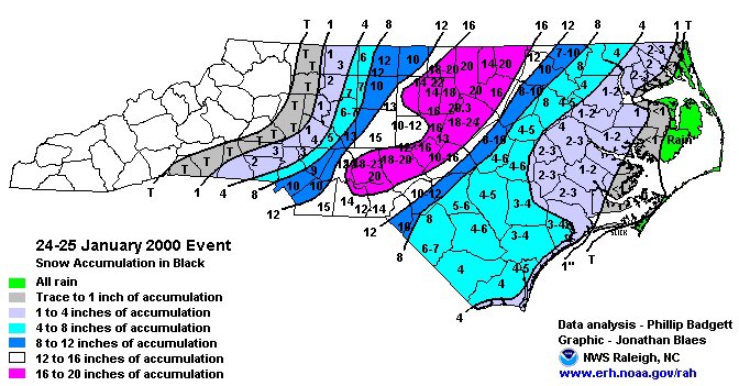
The most common and dangerous winter weather systems which can produce snow and ice are strong coastal low pressure systems known as nor’easters. This was the case back on January 24-25, 2000, when more than a foot of snow fell across parts of North Carolina. In addition behind the system, often we can experience a period of very cold weather. This happened with the early January 2018 storm when many locations had morning lows below zero, behind the system. This can make driving and walking extremely dangerous. Winter storms can be deceptive killers because most deaths are indirectly related to the storm. People die in traffic accidents on icy roads, have heart attacks while shoveling snow, or succumb to fires or carbon monoxide while trying to heat their home improperly.
Stay informed on the possibility of inclement weather and be prepared should it happen. If you are using any fuel-fired heat sources or equipment you should always have a working carbon monoxide detector and smoke alarms. During winter weather events, emergency managers advise that the best way to stay safe is to stay informed and pay close attention to the latest forecast.
- Winter Storm Watch is issued when conditions are favorable for either heavy snow, sleet, or freezing rain within the next 24-48 hours.
- Winter Weather Advisory is issued when wintry weather is expected and residents should exercise caution as light to moderate amounts of snow, sleet, or freezing rain are expected within the next 12-36 hours, causing travel difficulties.
- Winter Storm Warning is issued when confidence is high that a winter storm will cause significant impacts within the next 12-36 hours.
If you must travel during bad weather, emergency officials remind motorists to leave plenty of room between you and other vehicles and, if driving on snow- or ice-covered roadways, reduce your speed. If conditions worsen, pull off the roadway and remain in your vehicle. Do not set out on foot unless you can see a building close by where you can take shelter. You should also store an emergency kit in your vehicle that includes a scraper, jumper cables, tow chain, sand/salt, blankets, flashlight, first aid kit and a road map.
Don’t forget to include pets in your emergency plans. To keep animals safe during winter weather, emergency management officials recommend you:
Make an emergency supplies kit for your pet and include medical records, first aid kit, enough canned/dry food and water for three to seven days and a pet travel bag or carrier.
Do not leave pets outside for long periods of time.
Ensure your pet has a well-fitting collar.
Bring pets inside when temperatures drop below freezing.
Move livestock and other animals to a sheltered location with food and water.
For more information on how to prepare for winter storms, visit www.readync.gov.