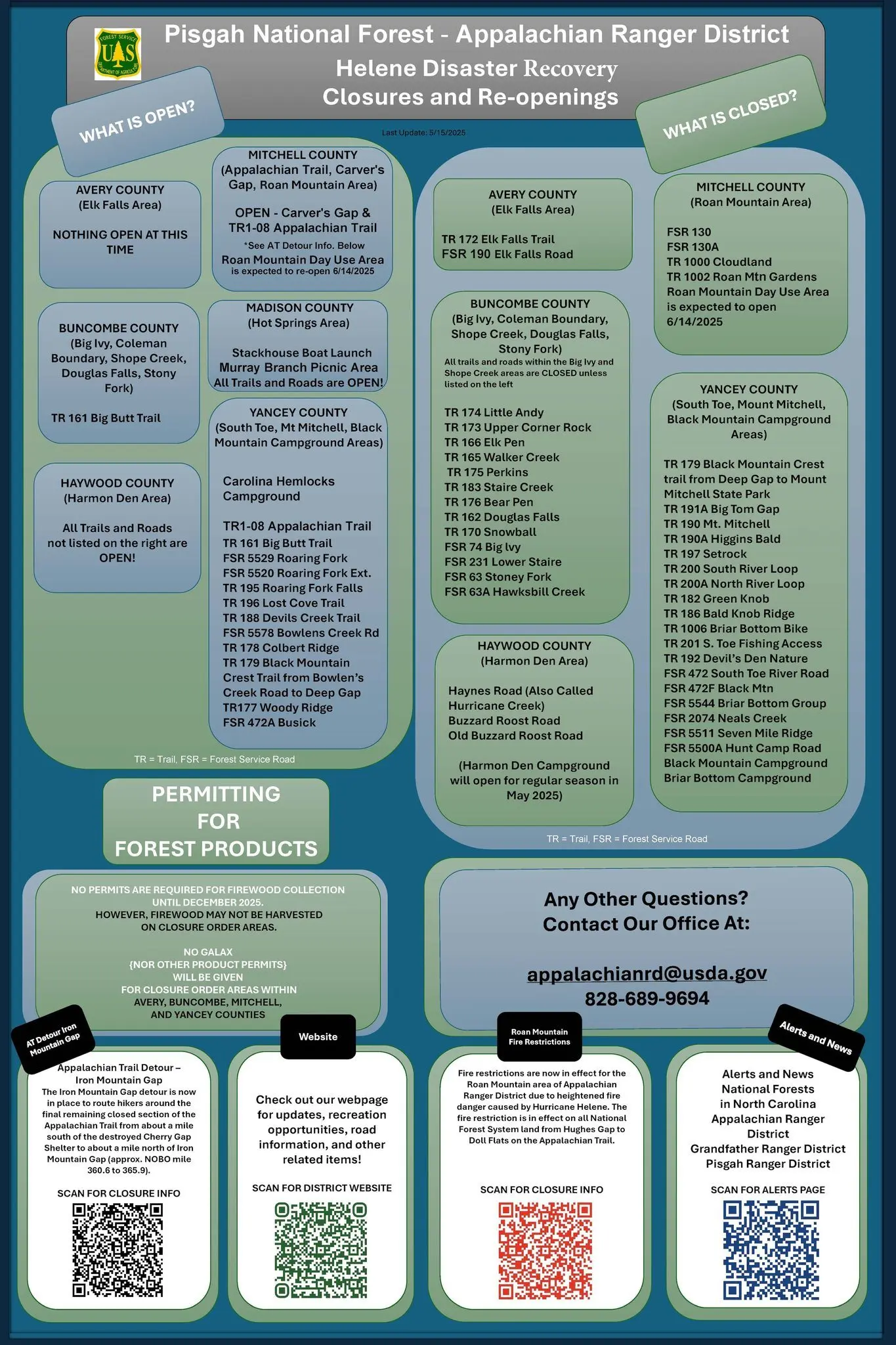


The USDA Forest Service has announced that several trails and recreation sites damaged by Hurricane Helene have reopened across the Appalachian Ranger District on the Pisgah National Forest.
With the support of partners and volunteers, the Forest Service has successfully cleared 227 miles of trails on the Appalachian Ranger District since the storm struck last year, accounting for 70 percent of the district’s trails. This includes more than 114 miles of the Appalachian Trail.
Recently reopened sites include:
- Carolina Hemlock Campground
- Murray Branch Picnic Area
- Stackhouse Boat Launch
- Roaring Fork Falls Trail
- Colbert Ridge Trail
- Woody Ridge
- Black Mountain Crest Trail (from Bowlen’s Creek Rd to Deep Gap)
- Big Butt Trail
The Appalachian Ranger District has surveyed and cleared nearly 240 miles of roads across the district to date, accounting for nearly 76 percent of the district’s roads and providing improved access to first responders and local residents.
While the majority of the trails on the Appalachian Ranger District have reopened, several popular areas, such as Shope Creek, Big Ivy and portions in the South Toe, remain closed due to ongoing public safety hazards. Violating Helene-related closure orders on the Pisgah National Forest can divert valuable time and resources from recovery efforts.
When visiting sites that have reopened, the public should use extra caution when spending time in the Pisgah National Forest this summer, as conditions on the ground may have changed since Helene. In addition, larger crowds can be expected over the holiday weekend.
The following recreation sites and trails remain closed to visitors:
Avery County (Includes Elk Falls Area)
- TR 172 Elk Falls Trail
- Elk Falls Road
Buncombe County: (Includes Big Ivy, Coleman Boundary, Shope Creek, Douglas Falls, Stony Fork)
- TR 174 Little Andy
- TR 173 Upper Corner Rock
- TR 166 Elk Pen
- TR 165 Walker Creek
- TR 175 Perkins
- TR 183 Staire Creek
- TR 176 Bear Pen
- TR 162 Douglas Falls
- TR 170 Snowball
- FSR 74 Big lvy
- FSR 231 Lower Staire
- FSR 63 Stoney Fork
- FSR 63A Hawksbill Creek
Haywood County (Includes Harmon Den Area)
- Haynes Road (Also Called Hurricane Creek)
- Buzzard Roost Road
- Old Buzzard Roost Road
Mitchell County (Includes the Roan Mountain Area)
- Poplar Boat Launch
- FSR 130
- FSR 130A
- TR 1000 Cloudland
- TR 1002 Roan Mountain Gardens
Yancey County (Includes South Toe, Mount Mitchell)
- TR 179 Black Mountain Crest trail from Deep Gap to Mount Mitchell State Park
- TR 191A Big Tom Gap
- TR 190 Mt. Mitchell
- TR 190A Higgins Bald
- TR 197 Setrock
- TR 200 South River Loop
- TR 200A North River Loop
- TR 182 Green Knob
- TR 186 Bald Knob Ridge
- TR 1006 Briar Bottom Bike
- TR 201 S. Toe Fishing Access
- TR 192 Devil’s Den Nature
- FSR 472 South Toe River Road
- FSR 472F Black Mtn
- FSR 5544 Briar Bottom Group FSR 2074 Neals Creek
- FSR 5511 Seven Mile Ridge
- FSR 5500A Hunt Camp
- Black Mountain Campground
- Briar Bottom Campground
For more information openings and closings across the entire Pisgah National Forest, visit www.fs.usda.gov/nfsnc and follow the National Forests in North Carolina on Facebook at www.facebook.com/nfsnc.
See Maps and Closure Orders Here.